
|
Home -:- Site
map -:- Links -:- Print resources History of Freeland, Pa. Street views |
|
|
Home -:- Site
map -:- Links -:- Print resources History of Freeland, Pa. Street views |
| Early accounts 1873 Freehold map More 1873 maps Municipal matters Businesses Places of worship People Organizations Schools Entertainment Transportation Street names Buildings Newspapers |
There were quite a few postcards produced back in the day that showed street views of Freeland. Some of them are reproduced here. If you have any others, I would be interested in purchasing copies of them. The view at the top of this page shows Centre Street looking north from Main Street. That's the Birkbeck Block in the left foreground -- a large building which housed William Birkbeck's hardware and plumbing business, and later a succession of other businesses. This is apparently a rare view, and I only have this poor-quality digital image, so I can't provide a larger view without making it totally blurry. If you happen to know someone who owns a copy of this postcard, would you please let me know? I would like to purchase a copy of it for my files. A few of the following views are provided courtesy of J. Zubach. STREETS RUNNING NORTH-SOUTH: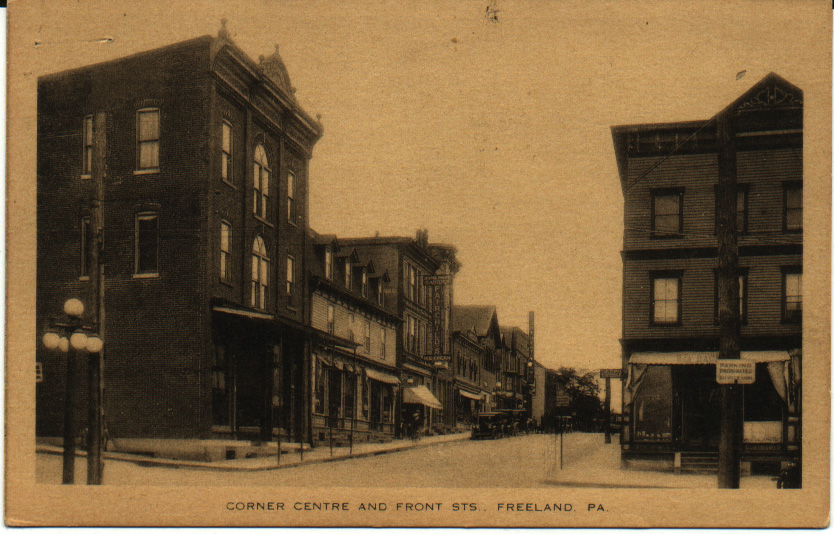 Centre and
Front Streets, looking north. On the right you see William
A. Bachman's optometrist office; he also dealt in watches
and clocks at the same location. On the left, on the corner,
is Amandus Oswald's general store. Two other signs are legible
on the west side of the street: "Home-made Candies - Fairchild's
- Ice Cream" and "Light Heat Power". Many of these buildings are
still standing and still identifiable.
Centre and
Front Streets, looking north. On the right you see William
A. Bachman's optometrist office; he also dealt in watches
and clocks at the same location. On the left, on the corner,
is Amandus Oswald's general store. Two other signs are legible
on the west side of the street: "Home-made Candies - Fairchild's
- Ice Cream" and "Light Heat Power". Many of these buildings are
still standing and still identifiable.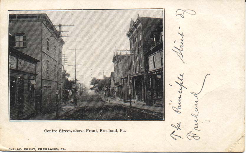 Looking south from just above
Centre and Front Streets. At the left of the picture, in
the foreground, is the print shop where the Semi-Weekly Progress
newspaper was printed. Across the street you can see Amandus Oswald's
general store on the corner, with its.covered entryway. There
are several trees visible on the next block, including the one
or two in front of the Central Hotel.
Looking south from just above
Centre and Front Streets. At the left of the picture, in
the foreground, is the print shop where the Semi-Weekly Progress
newspaper was printed. Across the street you can see Amandus Oswald's
general store on the corner, with its.covered entryway. There
are several trees visible on the next block, including the one
or two in front of the Central Hotel.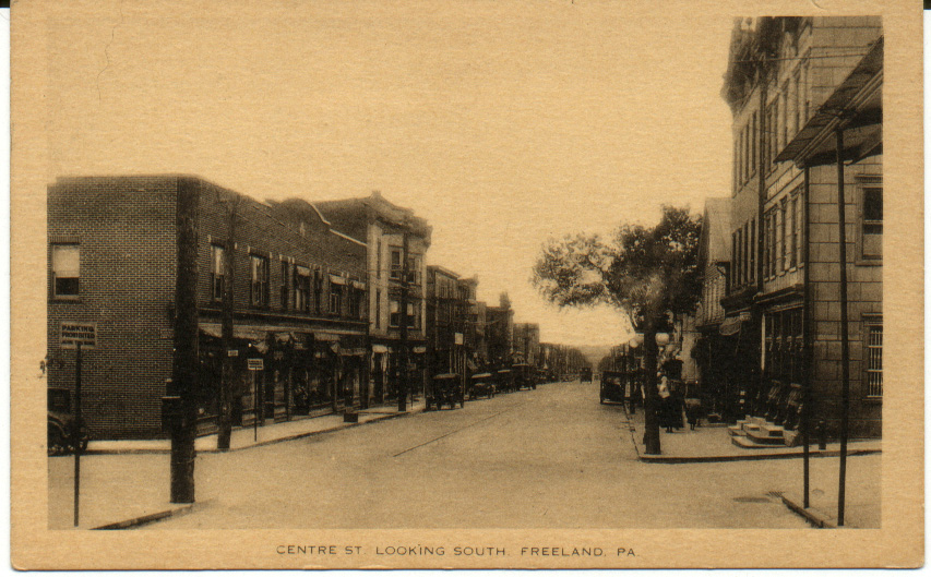 Centre and
Front Streets, looking southeast. On the right, the First
National Bank stands on the corner. I'm not sure, but I think
that the tree on the right is in front of the Central Hotel,
which is set back slightly and not visible in this view. Compare
this view to the next one, which shows the Central Hotel and the
Citizens Bank. Again, a number of these buildings are still there
and still recognizable. Notice the trolley tracks.
Centre and
Front Streets, looking southeast. On the right, the First
National Bank stands on the corner. I'm not sure, but I think
that the tree on the right is in front of the Central Hotel,
which is set back slightly and not visible in this view. Compare
this view to the next one, which shows the Central Hotel and the
Citizens Bank. Again, a number of these buildings are still there
and still recognizable. Notice the trolley tracks.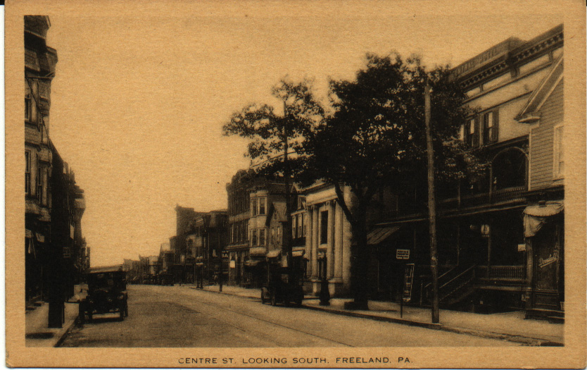 Centre Street,
looking southwest toward the Central Hotel and the Citizens
Bank. Next to the Central Hotel might be Steven B. Dvorshak's
grocery and meat market (it's a little hard to read the sign,
but the location is about right). Again, recognizable biuldings and
trolley tracks. The Central Hotel also contained a livery stable
and a number of other businesses that rented office or shop space
from the proprietor, M. H. Hunsicker.
Centre Street,
looking southwest toward the Central Hotel and the Citizens
Bank. Next to the Central Hotel might be Steven B. Dvorshak's
grocery and meat market (it's a little hard to read the sign,
but the location is about right). Again, recognizable biuldings and
trolley tracks. The Central Hotel also contained a livery stable
and a number of other businesses that rented office or shop space
from the proprietor, M. H. Hunsicker.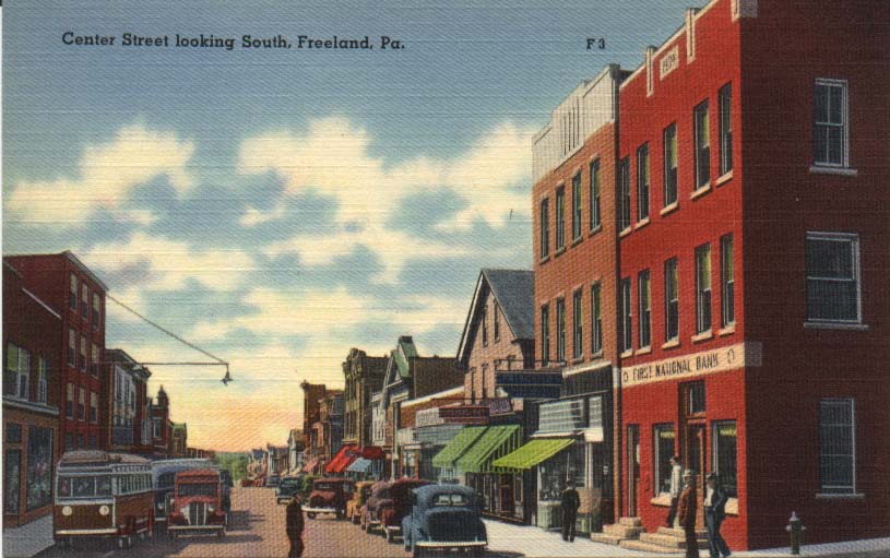 Another view
looking southeast at Centre Street from Front Street. On
the right, the First National Bank stands on the corner. No
more Central Hotel, no more trees, no trolley tracks, and look
at the cars and buses! Also notice the unusual street light on the
left side of the picture, hanging out over the street. Compare this view
to the one above of Centre and Front Streets, looking southeast. Similar
perspective, but a very different time period.
Another view
looking southeast at Centre Street from Front Street. On
the right, the First National Bank stands on the corner. No
more Central Hotel, no more trees, no trolley tracks, and look
at the cars and buses! Also notice the unusual street light on the
left side of the picture, hanging out over the street. Compare this view
to the one above of Centre and Front Streets, looking southeast. Similar
perspective, but a very different time period.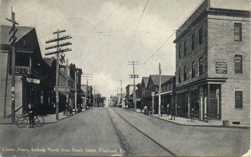 Centre Street,
looking north from South Street. This is a great picture,
especially in light of the recent new contruction on this site.
In thie photo, on the left in the foreground is the Valley
Hotel (with a balcony), and next to it a drug store. On the right
in the foreground, real estate and insurance offices. On the right,
all the way in the background, you can see what looks like a church
steeple. It's the borough building, which at this time still had
a steeple. See the photo on my "Municipal Matters" page.
Centre Street,
looking north from South Street. This is a great picture,
especially in light of the recent new contruction on this site.
In thie photo, on the left in the foreground is the Valley
Hotel (with a balcony), and next to it a drug store. On the right
in the foreground, real estate and insurance offices. On the right,
all the way in the background, you can see what looks like a church
steeple. It's the borough building, which at this time still had
a steeple. See the photo on my "Municipal Matters" page.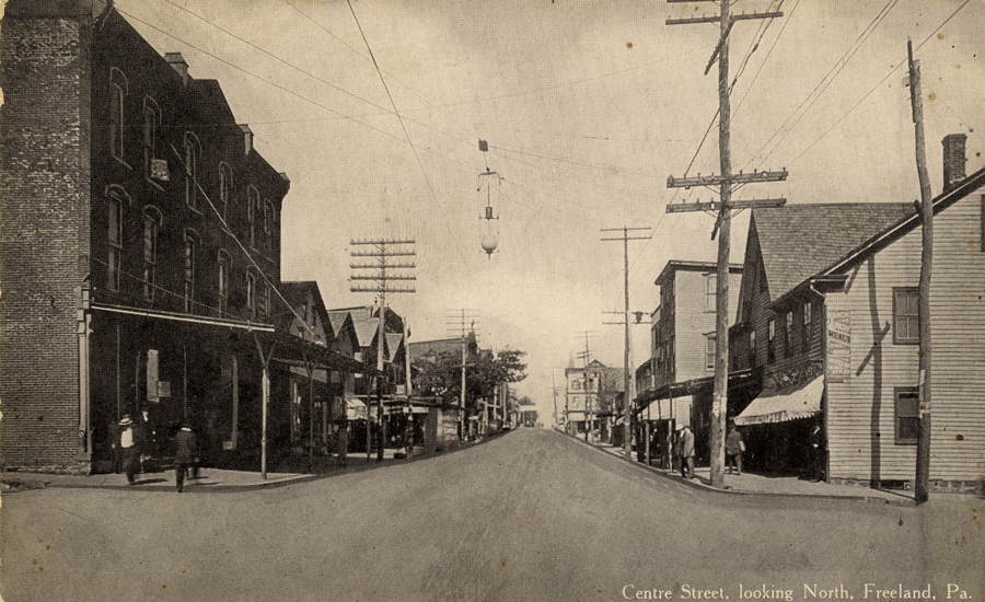 Centre and Main
Streets, looking north. On the left, on the corner, is
the Birkbeck block. The tree halfway up the block marks the location of
the Central Hotel. In the far distance at the top right you can see that
steeple on the Municipal Building. Many of the buildings visible in
this picture are still standing and still identifiable.
Centre and Main
Streets, looking north. On the left, on the corner, is
the Birkbeck block. The tree halfway up the block marks the location of
the Central Hotel. In the far distance at the top right you can see that
steeple on the Municipal Building. Many of the buildings visible in
this picture are still standing and still identifiable.STREETS RUNNING EAST-WEST: 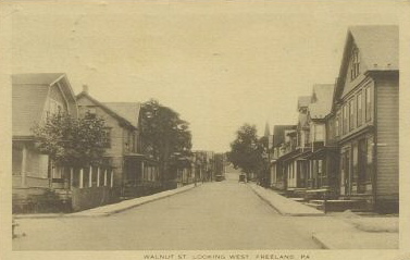 This view shows
Walnut Street, looking west toward Centre Street from a block or
two east of it (from Washington or Pine Streets?). The building at
right in the foreground looks like a storefront, but I only have this
low resolution digital photo and so I can't see enough detail to
be able to tell. You can see the steeple of the borough building in
the back right area of the photo.
This view shows
Walnut Street, looking west toward Centre Street from a block or
two east of it (from Washington or Pine Streets?). The building at
right in the foreground looks like a storefront, but I only have this
low resolution digital photo and so I can't see enough detail to
be able to tell. You can see the steeple of the borough building in
the back right area of the photo.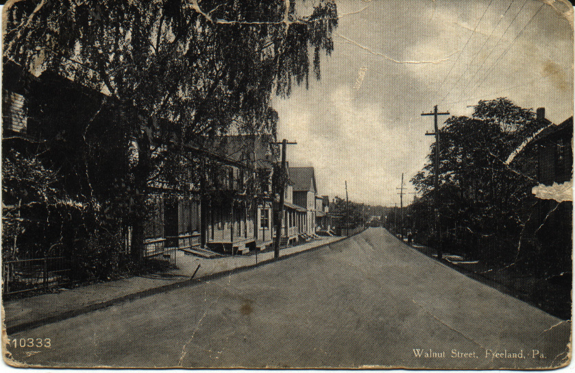 Here we're
looking east on Walnut Street toward Birkbeck Street, which you
can see at the end of the street. The buildings on this street
are mostly homes, as is the case today. There were some nice, large
trees along this street. The second building from the left edge of the
picture looks like a storefront of some kind, and has wooden doors
in the sidewalk in front that would lead to the basement.
Here we're
looking east on Walnut Street toward Birkbeck Street, which you
can see at the end of the street. The buildings on this street
are mostly homes, as is the case today. There were some nice, large
trees along this street. The second building from the left edge of the
picture looks like a storefront of some kind, and has wooden doors
in the sidewalk in front that would lead to the basement.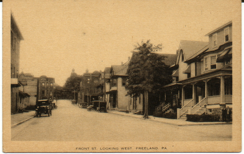 This is a great
image, looking toward the intersection of Centre and Front Streets
from about a half block east of the intersection, on Front Street.
On the right you can see the sign for Sharp's Bakery. At the intersection
across Centre Street you can see De Pierro's on the left (where the
bank is now) and Oswald's general store on the right. The twin steeples
of St. Mary's Church are visible in the background on the right. There
were some nice-sized trees along the street, too.
This is a great
image, looking toward the intersection of Centre and Front Streets
from about a half block east of the intersection, on Front Street.
On the right you can see the sign for Sharp's Bakery. At the intersection
across Centre Street you can see De Pierro's on the left (where the
bank is now) and Oswald's general store on the right. The twin steeples
of St. Mary's Church are visible in the background on the right. There
were some nice-sized trees along the street, too. Here's a view
from a couple of decades later, standing at the intersection of
Front and Centre Streets and looking east toward the Public Park instead
of west. Unfortunately I only have this low resolution digital
photo, and so I can't provide any more detail or a clearer image
than this. There are several recognizable buildings in this photo.
Here's a view
from a couple of decades later, standing at the intersection of
Front and Centre Streets and looking east toward the Public Park instead
of west. Unfortunately I only have this low resolution digital
photo, and so I can't provide any more detail or a clearer image
than this. There are several recognizable buildings in this photo.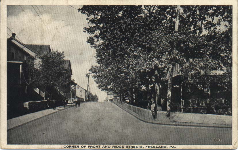 This postcard
shows the view from the intersection of Front and Ridge Streets,
looking north toward Walnut Street. This was a quiet residential
area at the time of the photo, even more so than it is today, and
although you can't see it here, the Bethel Baptist Church is at the
end of the block ahead on the right.
This postcard
shows the view from the intersection of Front and Ridge Streets,
looking north toward Walnut Street. This was a quiet residential
area at the time of the photo, even more so than it is today, and
although you can't see it here, the Bethel Baptist Church is at the
end of the block ahead on the right. 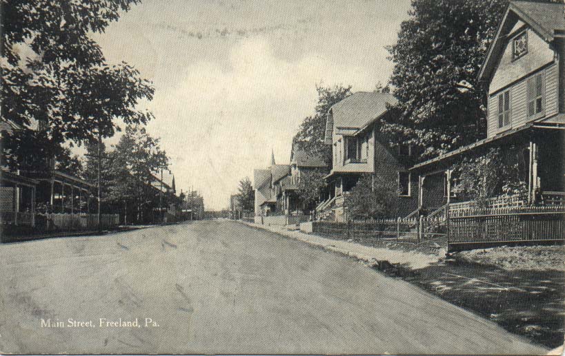 This shows
some beautiful homes with fenced lawns and yards, and quite a
few trees along the street. The church steeple visible at right in
the background is the original St. Luke's Lutheran Church, a wooden
building that was later replaced by stone construction. I can't
tell what's at the far end of the street -- trees? The Public Park is
behind the person who photographed this view.
This shows
some beautiful homes with fenced lawns and yards, and quite a
few trees along the street. The church steeple visible at right in
the background is the original St. Luke's Lutheran Church, a wooden
building that was later replaced by stone construction. I can't
tell what's at the far end of the street -- trees? The Public Park is
behind the person who photographed this view.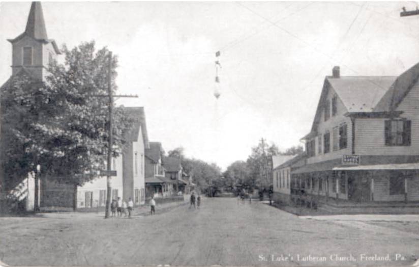 Here's another
view from about a block up the street and facing the other direction,
toward the park. The original St. Luke's is on the left, and the Cottage
Hotel is on the right. This is another one that I only have this one
low-resolution digital image of, and so I can't provide better detail
at present. Still, it's enough to give you a sense of what that neighborhood
looked like.
Here's another
view from about a block up the street and facing the other direction,
toward the park. The original St. Luke's is on the left, and the Cottage
Hotel is on the right. This is another one that I only have this one
low-resolution digital image of, and so I can't provide better detail
at present. Still, it's enough to give you a sense of what that neighborhood
looked like.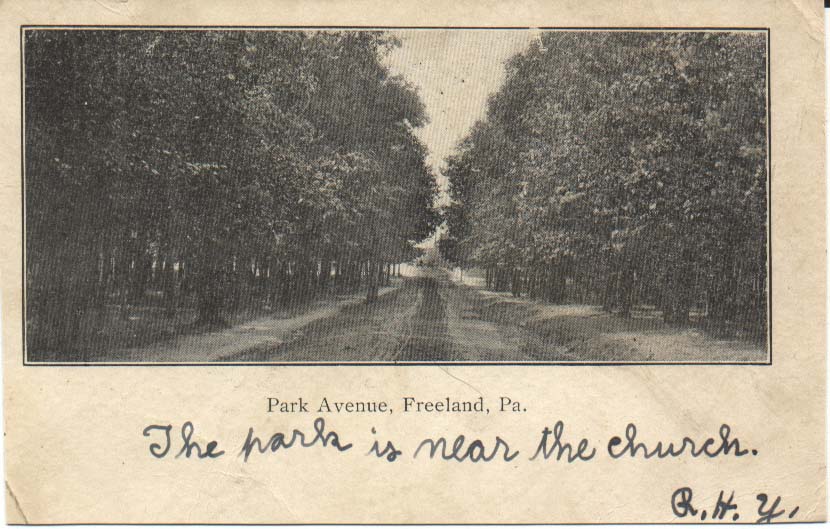 This is kind
of an odd view. It shows an unpaved roadway through the park,
looking westward toward the east end of Main Street, where the Park
M. E. Church is. The caption of this postcard says, "Park Avenue,
Freeland, Pa." You can see that at this time the park was still
rather densely wooded.
This is kind
of an odd view. It shows an unpaved roadway through the park,
looking westward toward the east end of Main Street, where the Park
M. E. Church is. The caption of this postcard says, "Park Avenue,
Freeland, Pa." You can see that at this time the park was still
rather densely wooded.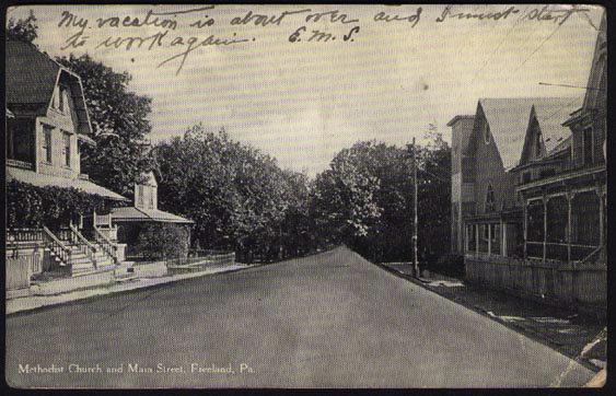 In this view,
the photographer was standing about a half block west of the Park
M. E. Church, facing east toward the Public Park. You can see the
church, the last building on the right. The postmark on this postcard
is dated 1912, so while we don't know what year this photo was taken,
we at least know that it's no later than 1912.
In this view,
the photographer was standing about a half block west of the Park
M. E. Church, facing east toward the Public Park. You can see the
church, the last building on the right. The postmark on this postcard
is dated 1912, so while we don't know what year this photo was taken,
we at least know that it's no later than 1912. |